


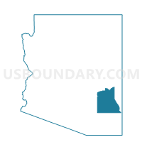
Solomon 1 Voting District, Graham County, Arizona
About
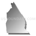
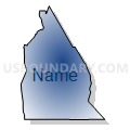
Outline

Summary
| Unique Area Identifier | 523844 |
| Name | Solomon 1 Voting District |
| County | Graham County |
| State | Arizona |
| Area (square miles) | 895.07 |
| Land Area (square miles) | 891.66 |
| Water Area (square miles) | 3.41 |
| % of Land Area | 99.62 |
| % of Water Area | 0.38 |
| Latitude of the Internal Point | 32.66403110 |
| Longtitude of the Internal Point | -109.43683040 |
Maps


Graphs
Select a template below for downloading or customizing gragh for Solomon 1 Voting District, Graham County, Arizona


Neighbors
Neighoring Voting District (by Name) Neighboring Voting District on the Map
- Bonita 13 Voting District, Graham County, AZ
- Clifton 1 Voting District, Greenlee County, AZ
- Duncan Voting District, Greenlee County, AZ
- Eagle Voting District, Greenlee County, AZ
- Morenchi Voting District, Greenlee County, AZ
- Peridot 16 Voting District, Graham County, AZ
- Precinct 12, Cochise County, AZ
- Precinct 31, Cochise County, AZ
- Safford 15b Voting District, Graham County, AZ
- Safford 2 Voting District, Graham County, AZ
- Safford 3 Voting District, Graham County, AZ
- Thunderbird 14 Voting District, Graham County, AZ
Top 10 Neighboring County Subdivision (by Population) Neighboring County Subdivision on the Map
- Safford CCD, Graham County, AZ (24,993)
- Clifton CCD, Greenlee County, AZ (5,849)
- San Carlos CCD, Graham County, AZ (4,780)
- Bonita-Klondyke CCD, Graham County, AZ (3,153)
- Duncan CCD, Greenlee County, AZ (2,588)
- Bowie CCD, Cochise County, AZ (1,971)
Top 10 Neighboring Place (by Population) Neighboring Place on the Map
Top 10 Neighboring Elementary School District (by Population) Neighboring Elementary School District on the Map
Top 10 Neighboring Unified School District (by Population) Neighboring Unified School District on the Map
- Safford Unified District, AZ (16,677)
- Morenci Unified District, AZ (2,878)
- Clifton Unified District, AZ (2,832)
- Duncan Unified District, AZ (2,653)
- San Simon Unified District, AZ (687)
- Bowie Unified District, AZ (608)
Top 10 Neighboring State Legislative District Lower Chamber (by Population) Neighboring State Legislative District Lower Chamber on the Map
Top 10 Neighboring State Legislative District Upper Chamber (by Population) Neighboring State Legislative District Upper Chamber on the Map
Top 10 Neighboring 111th Congressional District (by Population) Neighboring 111th Congressional District on the Map
Top 10 Neighboring Census Tract (by Population) Neighboring Census Tract on the Map
- Census Tract 9617, Graham County, AZ (4,911)
- Census Tract 9405, Graham County, AZ (4,780)
- Census Tract 9615, Graham County, AZ (4,449)
- Census Tract 9616, Graham County, AZ (3,161)
- Census Tract 9602, Greenlee County, AZ (2,963)
- Census Tract 9601, Greenlee County, AZ (2,886)
- Census Tract 9603, Greenlee County, AZ (2,588)
- Census Tract 1, Cochise County, AZ (1,971)
Top 10 Neighboring 5-Digit ZIP Code Tabulation Area (by Population) Neighboring 5-Digit ZIP Code Tabulation Area on the Map
- 85546, AZ (19,677)
- 85533, AZ (2,943)
- 85540, AZ (2,874)
- 85534, AZ (2,588)
- 85632, AZ (835)
- 85605, AZ (597)
- 85551, AZ (405)